What Are Aerial Photos Used For?
In today's ever-changing building industry scene, technological integration has become an essential component of our processes. Aerial photographs, formerly reserved for amateurs and geographers, now play an important role in architects' toolkits. Let's look at how aerial images can be used in real-world scenarios.
Site Analysis and Contextual Understanding
Aerial images provide architects with a unique viewpoint on a project location that ground-level studies may not capture. This broader perspective aids in comprehending the site's context, surrounding structures, and the general environment, allowing for more informed design selections.
Topographical Insights
Aerial imagery illustrates a site's geography in detail, providing valuable insights. This knowledge is critical for architects working on projects with different elevations because it helps them visualise slopes, natural features, and potential drainage issues.
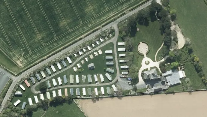
Urban Planning
Aerial images can help architects examine existing structures and plan new developments for better urban planning and zoning compliance. Additionally, these photos help to evaluate zoning rules and ensure compliance with local building codes.
Progress Monitoring
Architects can use aerial images to track progress during building. This provides a detailed assessment of the site, assisting in the identification of potential concerns and ensuring that construction is consistent with the original design objective.
Client Presentations
Aerial images provide effective visual aids for client presentations. Architects can effectively communicate design concepts by including these photographs in project presentations, emphasising how the proposed structure blends with its environment.
Environmental Impact Assessment
Architects are increasingly concerned with the environmental impact of their creations. Aerial photographs aid in assessing the existing ecosystem surrounding a place, allowing for a more environmentally conscious approach to development and landscaping. (https://www.environmentalscience.org/principles-applications-aerial-photography)
Archeological Discoveries
Aerial photography is an important technique in archaeological research (https://historicengland.org.uk/research/methods/airborne-remote-sensing/aerial-photographs/), providing a unique view of ancient landscapes. Archaeologists can effectively examine huge regions using high-resolution imaging and drone technology, locating probable sites and detecting minor details such as crop markings that suggest buried buildings. The capacity to capture differences in flora and soil colour helps to identify subsurface archaeological features, which contributes to our understanding of previous human activity. Aerial views provide a greater geographic perspective, making it easier to understand particular discoveries in light of their historical and cultural context. Repeat aerial surveys throughout time also help to monitor landscape changes, providing insights into site growth and the impact of human and natural processes.
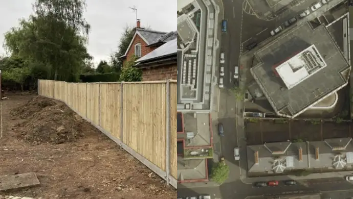
Boundary Disputes
Aerial photos can be pivotal in resolving boundary disputes by providing clear, unbiased, and comprehensive visual evidence of the land in question. these images offer a bird's-eye view that captures precise details of property lines, physical landmarks, and natural features that are crucial for determining the exact boundaries. By comparing current aerial photos with historical ones, changes in the landscape and encroachments can be identified, offering a chronological perspective on how the land has been used and altered over time. this visual documentation can be presented in legal proceedings to support claims, clarify misunderstandings, and assist surveyors and legal professionals in making informed decisions. ultimately, aerial photos serve as an authoritative source of information that tin help resolve disputes more efficiently and accurately.
To summarise, the use of aerial images in the building sector is more than just a trend; it is a genuine improvement to our design processes. As architects, we respect these photos' potential to convey a thorough understanding of a site, resulting in more contextually aware and well-informed architectural solutions.